


I live in Fredericksburg, Virginia, southern Spotsylvania County to be exact. There are dozens of roadside Historical Markers in the area with many more reaching out in all directions. The vast majority of these signs are related to the Civil War, but if you look carefully, you can find markers acknowledging the Colonial-era. Unfortunately, they tend to be quite obscure and in places that you would never think of going. I find this rather disappointing and have always felt that the region neglects far too much of its earliest history. These roadside markers provide a great opportunity to remind visitors that Fredericksburg had a life and legacy before 1862.
One marker that I pass every morning is the E 46 Colonial Fort sign. Erected in 2004 by Department of Historic Resources, it is located on Tidewater Trail (Virginia Route 2) 1.1 miles east of Lansdowne Road, on the right when traveling east. (It is also a few hundred yards up the road from the site of the Slaughter Pen.) The marker reads:
The Virginia General Assembly authorized the construction of a fort built nearby along the Rappahannock River in 1676. It served as a defensive fortification for settlers of European descent on the frontier when periodic conflicts occurred between Virginia Indians and settlers. Maj. Lawrence Smith commanded the fort. Smith had patented 6,300 acres of property with Robert Taliaferro in the region in 1666. Smith later obtained more land nearby. The fort was abandoned about 1682, when the General Assembly ordered the dismantling of many of these structures.
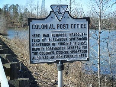
A short distance away is a much older marker titled N-10 Colonial Post Office. Erected in 1928 by the Conservation & Development Commission, this sign is also located on Tidewater Trail (Virginia Route 2) 0.6 miles east of Jim Morris Road (County Route 609), on the left when traveling east. It states:
Here was Newpost, headquarters of Alexander Spotswood (Governor of Virginia, 1710-22), Deputy Postmaster General for the colonies, 1730-39. Spotswood also had an iron furnace here.
Ironically, this region is still quite rural when compared to the surrounding county. The post office sign stands near Ruffin's Pond and the fort marker is adjacent to a cornfield. I plan to do some additional research into these two sites and will share my findings. I also invite anyone who may be familiar with these markers, or the history behind them, to comment below. Perhaps we can collectively add to their story.
(Image Source: HMdb.org)
Updated: Wednesday, 2 June 2010 8:15 AM EDT
Permalink | Share This Post
